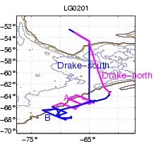
Long-Term Ecological Research on the Antarctic Marine Ecosystem: An Ice-Dominated Environment (LTER)
Jan - Jan, 2002
examine data
or download
postscript of map or (back to top)
or link to JASADCP
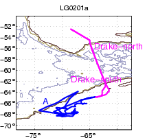
Southern Ocean Global Ocean Ecosystems Dynamics (SO GLOBEC): Circulation and Water Property Evolution
SO GLOBEC: Mysticete Whale Acoustic Census in the GLOBEC West Antarctic Project Area
International Whaling Consortium
Feb - Mar, 2002
examine data
or download
postscript of map or (back to top)
or link to JASADCP
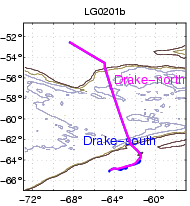
Mooring Recovery
Mar - Mar, 2002
examine data
or download
postscript of map or (back to top)
or link to JASADCP
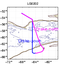
Palmer Shuttle
Mar - Apr, 2002
examine data
or download
postscript of map or (back to top)
or link to JASADCP
SO GLOBEC: Foraging Ecology of Crabeater Seals
SO GLOBEC: Seabird Ecology Using Observations and Diet Samples
SO GLOBEC: Krill Distribution, Physiology, and Predations; Copepod Prey Abundance
SO GLOBEC: Krill Age and Dietary History
SO GLOBEC: Mysticete Whale Acoustic Census in the GLOBEC West Antarctic Project Area
SO GLOBEC: Krill Physiology and Fish Ecology
Apr - May, 2002
examine data
or download
postscript of map or (back to top)
or link to JASADCP
Palmer Station Shuttle, Hazardous Waste on-load and refueling of Palmer Station
Jul - Jul, 2002
examine data
or download
postscript of map or (back to top)
or link to JASADCP
SO GLOBEC: Foraging Ecology of Crabeater Seals
SO GLOBEC: Seabird Ecology Using Observations and Diet Samples
SO GLOBEC: Winter Distribution and Activities of Sea-Ice Microbial Communities in the Western Antarctic Peninsula
SO GLOBEC: Optical Environment of the Western Antarctic Peninsula
SO GLOBEC: Winger Ecology of Larval Krill: Quantifying Their Interaction with the Pack Ice Habitat
Jul - Sep, 2002
examine data
or download
postscript of map (back to top)
or link to JASADCP
Palmer Station Shuttle #1
Sep - Oct, 2002
examine data
or download
postscript of map or (back to top)
or link to JASADCP
Palmer Station Shuttle #2
Foraging Behavior and Demography of Pygoscelis Penguins ( COPA Field Camp )
Oct - Oct, 2002
examine data
or download
postscript of map or (back to top)
or link to JASADCP
Cape Sherriff Field Camp Put-in/Opening
Automated Weather Station servicing at Racer Rocks and Hugo Island
COPA Field Camp pickup
Nov - Nov, 2002
examine data
or download
postscript of map or (back to top)
or link to JASADCP
The Scotia Arc GPS Project: Focus on the Antarctic Peninsula and South Shetland Islands
AMS radio carbon chronology of glacier fluctuations in the Sough Shetland Islands during the last glacial/interglacial hemicycle: Implication for the role of Antarctica in global climate change (Hall field camp put-in on Livingston Island)
Nov - Dec, 2002
examine data
or download
postscript of map or (back to top)
or link to JASADCP